How to Track Aircraft Carriers Like a Pro (Or a Lazy Genius)
Back in the Day…
Picture this: Aircraft carriers sailing the vast oceans, doing their thing, and no one can track them. Why? Because satellite technology was basically in its baby stage, and trying to find these massive ships was like trying to spot a needle in a haystack—on a windy day. They could operate in stealth mode (a bit like the secretive ninjas of the sea), and military operations often went undetected, just floating through the endless blue. But fast forward to today. Satellite technology has come a long way, and thanks to the rise of Open Source Intelligence (OSINT), everyone from ex-military folks to curious civilians and hobbyists has been tracking these colossal naval assets. Now, tracking an aircraft carrier isn't just for the secret service—it’s an accessible hobby, and some folks even use it for geopolitical analysis.
Let’s take a look at how it’s done!
Port Announcements
Ah, the joys of predictable human behavior! The U.S. Navy (and other Western naval powers) loves announcing when an aircraft carrier shows up at port. Not always in real-time, but it’s like they’re dropping breadcrumbs. For example, they’ll let everyone know when the USS Enterprise is docked at Norfolk or the USS George Washington is stopping by Yokosuka. Nice of them, right?
Strait Crossings (e.g., Suez Canal, Strait of Malacca)
Major global chokepoints like the Suez Canal and Strait of Malacca are heavily monitored. Aircraft carriers can’t sneak through without making a scene, so their movements are often tracked using maritime monitoring systems. They're not exactly easy to hide.
Social Media and Public Posts
Ah, the glory of social media. Every now and then, a sailor posts a cheeky pic or a video from their carrier (sometimes even with a geotag). Sometimes, you even get a real-time location update. It's like Twitter stalking, but with real-world results.
Tracking Tankers and Supply Ships
Aircraft carriers are big and need a lot of supplies. So, while the carrier itself might be stealthy, it travels with a fleet of support vessels like oilers and supply ships. By tracking these using AIS (Automatic Identification System), you can often get a solid lead on where the carrier is.
Tracking Navy Aircraft on FlightRadar
Got a thing for aircraft? Then this method is for you. Sometimes, Navy aircraft like helicopters and fighter jets are visible on FlightRadar24. While military aircraft have countermeasures, they can still pop up on civilian flight tracking systems, especially when they're doing predictable exercises. It’s like finding a treasure chest—but in the air.
Satellite Imagery
The big guns! Platforms like Google Earth, Sentinel Hub, and private satellite companies like Planet Labs let you monitor ships (including carriers) from space. These platforms offer high-res images that can help you track their movements and even identify the ship in the image. While military vessels might turn off their AIS, satellites can still capture them floating in the vast ocean. It’s like playing a real-life game of Where's Waldo but with super high-tech tools.
AIS (Automatic Identification System)
Military ships love to turn off their AIS to avoid being spotted, but civilian support vessels, like oilers, keep their AIS on. By tracking these, you can get a solid idea of where the aircraft carrier is, as these support ships often travel in the same path as the carrier.
Military Press Releases and News
The military can’t help themselves. They sometimes release information about carrier deployments, especially for major operations or exercises. If you're quick on the draw, you can scoop up this intel from news outlets or military releases and use it to track the carrier’s next move.
Commercial Maritime Traffic Data
Platforms like MarineTraffic or VesselFinder are like having a backstage pass to the ocean. They let you track not just commercial vessels, but military ones too. While carriers may turn off their AIS, other vessels in the fleet (like supply ships) will still be broadcasting their positions. Follow those and you can make an educated guess about where the carrier is hanging out.
Naval Exercise Schedules
The military loves to flex its muscle during joint operations and large-scale drills. When an aircraft carrier is part of these exercises, there's usually a public schedule that can give you a heads-up on where it’s going to be. Think of it like knowing when your favorite band is going on tour—except with more tanks.
Tracking for Noobs (aka Let’s Make it Easy)
Okay, grab your seats because we’re about to track an aircraft carrier using free tools. In this example, we’ll be tracking the USS George Washington (CVN-73), which recently visited the Japanese port of Yokosuka.
First things first: open Sentinel Hub’s EO Browser. Yeah, I know what you’re thinking—“Ugh, do I really have to?” But trust me, this part is actually pretty fun. Create an account (easy peasy), and then search for Yokosuka in Japan. Zoom in and guess what? You’ll spot a massive floating democracy—AKA, the USS George Washington. Pretty cool, right?
.jpg)
USS George Washington (CVN-73) at Yokosuka.
Amateur Tracking (Or How to Track an Aircraft Carrier Like You’re Hungry)
Alright, for the amateurs out there, let’s think of tracking an aircraft carrier like tracking food. Aircraft carriers aren’t hungry (they’ve got plenty of supplies), but we humans sure are! So, when we’re hungry, we either buy food or ask a friend for it. And when a carrier needs supplies, you’ll often find helicopters flying around, transporting cargo or personnel. You can track these helicopters on FlightRadar24. And just like that—boom—you've tracked the carrier.
Let’s Take a Look at This Example
Check out this Grumman C-2 from the Navy. If there’s a C-2 flying around, you can bet your bottom dollar that democracy is floating somewhere out there. So, what’s the next step? Head back to Sentinel Hub, plug in the coordinates, and zoom in on the area. (Okay, I’ll admit, I’m feeling lazy today too—so I’m not doing it either, but you get the idea).
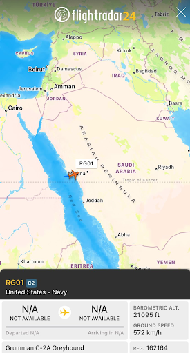
C2 GreyGound in Flightradar24
But here’s the best part: our great tracker of all time, MT Anderson, tracked this exact C-2 on March 9th and posted it on Twitter. He did the hard work, so props to him for that sweet intel!
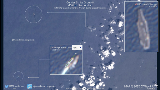
Mark Anderson's work
For the Advanced Guys
Alright, time to level up! Tracking aircraft carriers with satellites is like trying to fish with a rod that requires a PhD. You need to know satellite positions and the paths they follow, and let’s be honest—it takes some serious brainpower.
Low Earth Orbit (LEO) and Geostationary Orbit (GEO) satellites are your go-to tools here. But before you get all excited, know that satellite images aren’t perfect. You’ll deal with clouds, blurry images, and very short windows when satellites pass over. You’ve got to be quick, and you’ve got to be patient.
Want to take it up a notch? Check out Sentinel Hub, Google Earth Engine, or even commercial platforms like Planet Labs or Maxar. But here’s the catch: it’s not as easy as just pointing and clicking. You need some serious skills to decipher those images and figure out where the carrier is. So grab your coffee, get your brain in gear, and start hunting. You’ve got this!
Now that’s how you track an aircraft carrier. Easy, right? Well, kind of!